
I purchased a smartphone for navigation in 2012. As it turned out, it was the best gear swap-out I’d made in a long while. Smartphones make navigation a pleasure because the mapping is so easy and intuitive. I can quickly download detailed maps of any country in the world which are easy to zoom in and out of, move around, and create points of interest on.
Smartphones are perfect for most navigational needs.
How is a Smartphone Better than a Handheld GPS?

They are SO much more user-friendly than GPS devices. One of the biggest drawcards of smartphones are their touch screens; pinch and zoom and slide the maps around with ease. Mapping ‘apps’ are simple whereas GPS devices seem to be plagued with confusing menu systems. I use data points regularly, which are really easy to add and remove on a smartphone.
You don’t need a computer with you. You can download all your maps straight from the Apple App Store or Google Play Store.
The maps are current. Any of the decent mapping apps update their information really frequently.
They’re quicker and more accurate. The GPS chip in my iPhone 5S is faster and more accurate than in my Garmin Edge 800. GPS speed on smartphones is aided with mobile telephone infrastructure around the world.
They have a large screen. Bigger screen equals easier to read. Important when your device is an arms-length away.
Smartphones are multi-purpose. A smartphone is a phone, email device, photo editor, website editor… the list goes on!
They charge quickly. Just one hour in the wall has my phone charged from 0-100%.
How Do I Use My Smartphone to Navigate?
I make my routes on-the-go, generally as KML files which show my routes as lines on my maps. I sometimes like to mark points of interest at key intersections so that I don’t miss my turns. I tend to use my smartphone more like a paper map, switching it on/off whenever I need to check if I’m still en route and heading the right way. My smartphone screen remains off most of the day to conserve battery – I only switch it on to check where I am. I can go for days without a battery charge if I use my smartphone in this manner!
This resource shows you how to import a custom KML map into the Maps.me app (iPhone).
What are the Limitations of the Smartphone?
Battery life. I could ride for about 20 hours with my Garmin Edge 800 on the whole time. This is not at all possible on a smartphone without being connected to a dynamo hub, solar panel or external battery.
Wet weather. Sensitive touch screens become quite useless in the rain. I have a ‘poncho’ for my iPhone which helps when the screen has droplets on it but is far from perfect.
Screen Glare. Sometimes the sun comes in on the wrong angle whilst cycling and makes the glossy screen hard to see. If I do desperately need to check the GPS, I simply pull over and shade the screen.
As a bicycle computer. GPS devices often provide all kinds of bicycle computer data, and it’s true that a smartphone can do the same. But… the battery life will really suffer if you do this. I recommend having a cheap separate bicycle computer for recording ride data.
Charging Your Smartphone

Using my smartphone like a paper map, I’ve found that I use between 10-50% of the smartphones battery per day, depending on how many times the screen is switched on and off. If you have frequent access to power points (not hard in most parts of the world) you’ll be able to charge most smartphones within an hour.
Dynamo Hub Power
I have used dynamo power to keep everything topped up for the last 31,000km, and have just switched to the Tout Terrain The Plug III. A smartphone charge from the dynamo hub takes just 2-3 hours on the bike. You can read my List of Hub Dynamo Power Supplies for USB Devices for lots more information on hub charging.
I also have the Ultimate Power Resource: Dynamo Hubs, Solar Panels, Power Supplies and External Batteries which includes information on many different ways you can keep your smartphone charged.
Mounting Your Smartphone
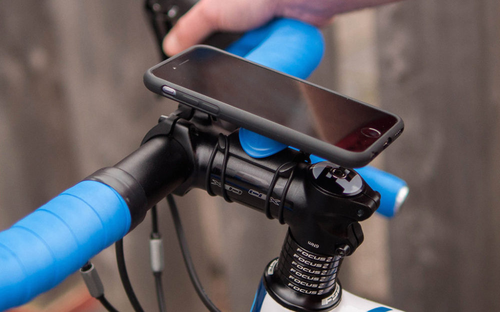
I use and recommend Quad Lock products for your bike mounting needs. They’re well designed, super slim, elegant and simple. You can read my review of the Quadlock Smartphone case.
I’ve recently put together a list of The Best Bike Smartphone Cases & Mounts for Cycling. This list features all of the best options available. Some mount on the stem, others on the handlebar itself, some go in front of the stem and others come off the top cap of your headset. Some cases are more waterproof and protective than others.

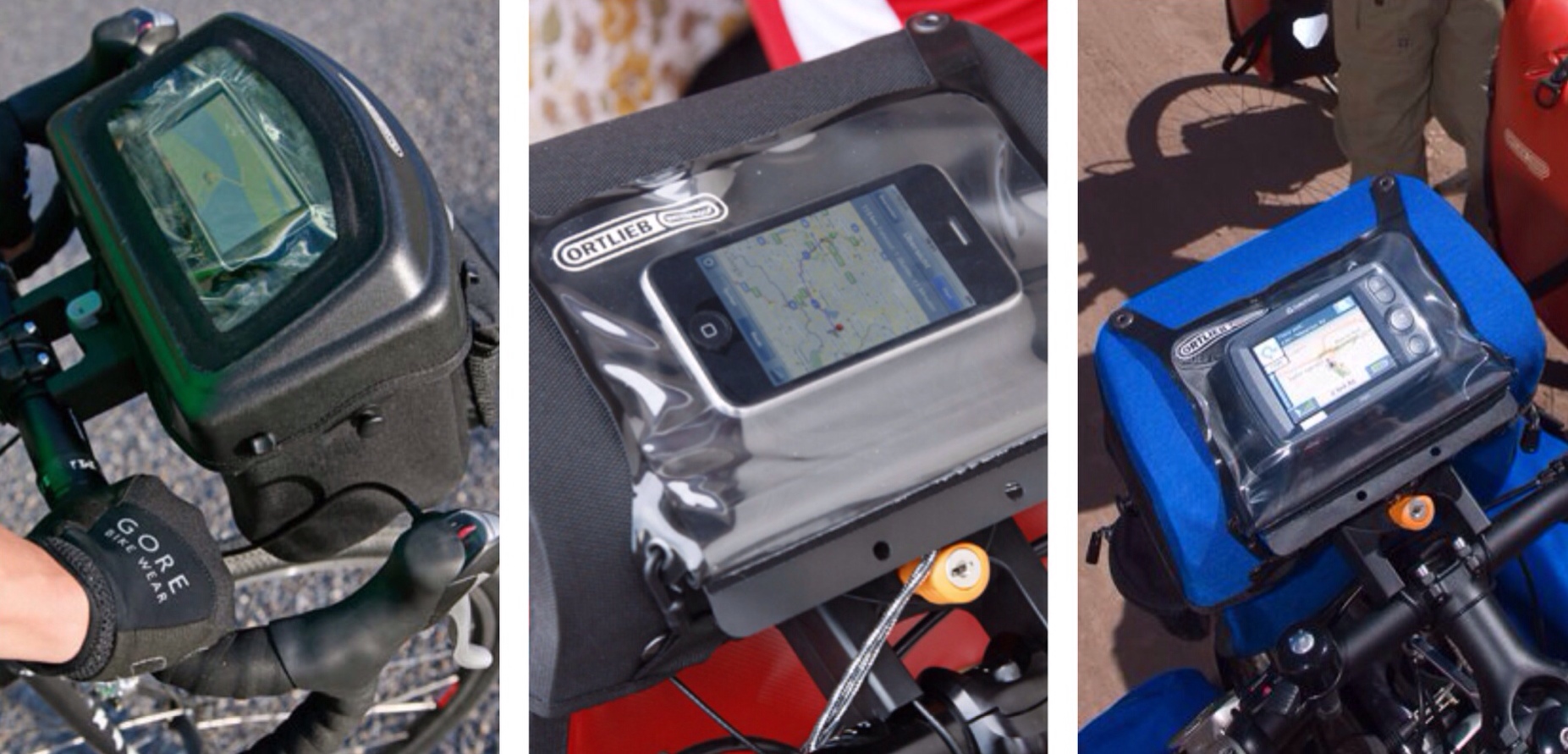
Ortlieb has recently updated its Ultimate 6 Pro handlebar bag to have a waterproof sleeve which allows you to slip your smartphone in and navigate. If you’re using an older Ortlieb handlebar bag, you can get a waterproof sleeve that connects onto the bags buttons.
Do You Need a SIM Card to Use the GPS Function?
No. Using GPS satellites is free, you’re just receiving a signal. If you have a GPS chip in your smartphone and have downloaded some maps for offline use, you will always be able to find where you are.
Waterproof Smartphones
It is possible to buy an Android smartphone which is impervious to dust, water and to some extent dropping, without using a ‘rugged’ cover. Rugged covers, although very handy for delicate smartphones, are often quite cumbersome and reduce the sensitivity of the touch screen interface.
Samsung makes a phone called the Galaxy S5 Active which is identical in all aspects to the highly popular Galaxy S5, except for the addition of armour and a few external buttons. The standard Galaxy S5 actually has the same waterproof rating of IP67 certification (submerged at 3 feet for 30 minutes), so if you’re not after the rugged form, this phone will fit the bill.
Sony makes a model called the Xperia Z3 (compact version available too) which has an even more impressive IP65/68 certification (submerged at 5 feet for 30 minutes). That said, in terms of ‘ruggedness’, the Sony is more on par with the standard Samsung Galaxy S5 than the Active.
Apple, unfortunately, do not produce a waterproof/shockproof phone yet.
Using a Tablet, iPad or iPod Touch
It is possible to use tablets and iPods for navigation, especially if they have a GPS chip built-in. If they don’t, there are plug-in products available to allow you to locate satellites. You can connect tablets to your bicycle with the Quadlock Universal mount.
What a review, wow, excellent job! Really packed with information. Thank you a lot!
I especially like the screenshots, it saves the usual struggle of downloading, installing, trying out, and also there is a visual image behind the name.
I already use many of your tips, and the others that I didn’t implement yet are in que for the future upgrades, like the hubdynamos.
My current struggle is mainly with elevation.
All GPS maps I came across so far on phones are “horizontal”, which is fine for cars. Steep elevations that can be a trouble for small engines are maybe marked, but otherwise they are “flat”.
However, for biking, small elevations that don’t matter for cars do matter for a heavily packed bike.
It happened to me 3-4x already during tours that the route we chose based on the map turned out be hillier than we wanted, although it didn’t look “that bad”.
Beside asking locals, and carefully interpreting what they say, and checkin elevation marks on paper maps, I haven’t found a good way to plan ahead longer tours with elevation information built in. I also read bike-touring books, which have some suggested bike routes with the elevation profile within.
Even with http://www.cycleroute.org/ is kind of a trial and error to find a good track in hilly areas.
Any ideas and tips in this matter are welcome.
Another quesiton I have: for the rare times when we rent a car and go by car, we use a Navigon 8450 GPS. This has the advantage that it offers 2 or 3 routes to the destination, with different characteristics.
Do you know any routing software that does this on the phone?
Do you use your own scanned paper (bike)maps, or downloaded scanned in (bike) paper maps, or do you rely on downloading the software’s own?
I am with Olee22. That is a very interesting post and whilst I am a happy Garmin 810 user at present you do have me re-thinking my possible future use of my phone.
Elevation is not an issue for us. I normally take a close look at our topographical maps before departing on a long ride, assessing what contour lines the road crosses. I make a graph in my head of what the elevation profile probably looks like and leave it at that. Another good app that we use occasionally is “Geo Elevation”. You can plot routes easily on your phone/tablet (although they aren’t of the road itself, rather a straight line between the data points) – it then gives you an accurate profile graph.
Definitely Sygic (iOS) but from memory, many of the turn-by-turn apps have this feature.
We download the maps available through the apps for offline use.
I sold my Edge 800, the screen is to way to small, maps cost to much, and garmin don’t give any after sales support. I am planning to use a Magellan Cyclo 105 cycling computer, and a Magellan explorist for navigation. I like bush hiking and cycling and I am well aware of the dangers of the Australian bush- something I will not trust a garmin product with! However I will use a smart phone for communications and a backup GPS.
I use MapMyRide for basic training but I also have the TomTom GPS app I use on my iPhone in the car, it now has a cycling option updated in it…that could possibly work well? It does chew up the power but I have a dynamo so not worried about that anymore…
Bade Elf is rubbish? I just used Bad Elf on my iPad mini with Sygic to navigate inside a car in Scotland in bad weather for three weeks and it never skipped a beat. IN fact I broke the unit and Bad Elf replaced within a day of me doing so while I was on the road! It didn’t even drop out in really really bad weather in the far north or in bad weather at Glen Coe. Ditto for Ireland and the Ring of Kerry. Are you sure you know how to use the unit? I have also used a Bade Elf with OZrunways/iPad to navigate while piloting a helicopter. have my doubts you used the unit correctly, since you have suggested in the article that your smart phone directly connects with satellites which it doesn’t. AGPS not GPS and AGPS requires connection a server doesn’t it.?
Hi Scott
What we have outlined is our experience with the Bad Elf, it simply didn’t function well for us. Going by what you’ve said, maybe we received a faulty unit?
A lot of people misunderstand A-GPS, and think it’s some faux GPS system. It’s not; A-GPS requires a GPS receiver to work, and GPS receivers are built into most smartphones these days. The advantage of the A-GPS system is that you can determine your current location much faster than normal, by using almanac data over a cellular network. What happens when you have no cellular data? The phone determines it’s position using the GPS receiver alone. Basically, A-GPS and cellular data aren’t necessary, but they’ll assist in providing your current location much quicker than without.
Alee
I don’t know what was wrong with your unit, but mine wasn’t faulty, I broke it. Although, a better design might see that the kind of break doesn’t happen in the future – and in fact putting this out to the Bad Elf people got me not only a replacement, but an upgrade. The people at Bad Elf are all class. All the criticisms I’ve read have been about design as opposed to pure performance of the Bad Elf Units. I can’t see how bicycle tours would tax the unit more than aviation and or a driving tour. I can’t see how for your purposes it didn’t work. As far as I understand AGPS it requires a phone signal or a wireless connection because assisted GPS needs to talk to the servers that talk to the satellites. But I’m not an expert. Your original comment that the Bad Elf is not recommended surprised me considering what I have put the unit through and it never failed until I broke it -with the help of a poor design. The Bad Elf Pro really impressed me in fact. I used it for a whole week…driving over a thousand miles before I even needed to recharge it. The most impressive thing however, were the people at the company. I’m a pretty tuff cookie and they softened me with some real classy customer service.
Not much of a gadget person and just recently have decided it might be a good idea to atleast make some effort to keep up with some technology if for no other reason than to know what the kids are talking about. 🙂
Last night rode with the new Moto G 4G lte and used the gps with google maps navigation on a 13 mile night ride to run a couple errands. It worked fine only lost signal a couple times. Didn’t use much phone battery at all after approximately two hours of biking, grocery shopping, etc. Kinda fun. I didn’t use any kind of stem mounting instead just tucked in small outside pocket of hydration pack. Phone has gorilla glass and is “splash proof” not going test those features. So far a really good phone for using google maps and gps for navigation. I have used it for delivery driving at work and it’s also better than my previous gps gadget. Excellent article here, wow very informative and good for the less tech savvy looking for information. Thanks!
Another excellent review from you guys, as always. Just found an app called BikeComputer yet another GPS nav app which has downloads of offline maps for route planning without having to run GPS all the time. Well reviewed and offline maps are included with Free version and there is a paid version with other features of course.
What smart phones have a gps chip?
Most smartphones have a GPS chip. You can check out the specs of every phone on Phone Arena (http://www.phonearena.com/phones/manufacturers). Click on the phone you’re interested in, and scroll down to “Technology” to see if it has “GPS”.
New to your blog and loving it 🙂
Couple of points:
I think a lot of the barriers-to-entry for using a smartphone as a bicycle computer start with the iPhone; rubbish non-changeable battery, fragile, no card. Many Android phones have replaceable batteries (I carry 3 spares= 4 days of use without charge, light, cheap [$10 for a spare battery]) and SDHC cards so easy to back up etc. Plus many are much more robust and weatherproof, e.g. new Z3
I like the Herbert and Richter universal bike mounts as they are relatively cheap, robust, and can fit any phone.
BTW, OSMAnd will track too.
All valid points – Android phones have many advantages, especially for bicycle touring.
Is it possible to follow premade ‘routes’ on any app like you can do on a garmin gps?
Strava will allow you to do that for iOS. Lots of the Android apps have that capability too.
But you will need a 3G/4G connection for this I presume? It d be annoying to get lost once your phone finds no connection :p
Can you import Garmin routes, guess not?
You’ll need data for Strava. Orux maps will allow you to import gpx files and run offline mapping (if you use an Android).
Ok, thanks for the swift reply! Do you have any experience with Runtastic apps? Android is not an option 🙁
In that case, buy Gaia GPS. You’ll be able to preview and download topo, street and aerial maps. You can then import and export your KML/GPX files (premade routes). https://itunes.apple.com/us/app/gaia-gps-topo-maps-trails/id329127297?mt=8&ign-mpt=uo%3D4
For Apple devices, one app worth mentioning is CoRider. For the use of importing a specific route (from Map my Ride or Ride with GPS for example), and then having the app give voice directions. Unfortunately for me, I’ve moved to Android which CoRider doesn’t support, so thanks for your article, I’ll be checking out Locus Map and others…!
Thanks for the recommendation! I’ll look into it.
Any cheaper options? This one costs 19.99 euros…
Hi DCB,
Do you know if you need a data 3G connection to let this app navigate you?
Regards,
Stefan
Great article ! 😉
hi, great article and great site. I’m a complete ignorant as far as technology. I was going to buy a garmin but after this detailed account I might buy a smartphone with gps. what I don’t get is how large a map you can download in you smartphone. Can I download the map of Europe or Asia and save the hassle of finding wifi points along the way, there must be a catch somewhere.
If you were me, what would you buy? I wouldn’t like to end up with a high tech thingy I can’t use. I just need directions and, maybe, a help in finding a campsite.
thank you
safe roads
Hi Ferruccio. You can download maps to your phone for entire continents! You do not need wifi once you’ve downloaded the maps, and you don’t need to connect to a cellular network to use the GPS – there is no catch. For example, using MapsWithMe, you buy the app once and have access to maps for every country in the world, which you can download when you please. Each country map is between 5-500mb in size and will often include points of interest such as campsites. Check out the ‘offline maps’ section for app options.
I wouldn’t use a GPS device again as smartphones and apps are now so powerful. The biggest downside is definitely the battery life – for long days you may need to have a battery pack, dynamo hub or solar charger to keep the phone running. Alee
thank you. since I use a dynamo I think I will definitely gor for a smartphone. I’ll let you know how it went.
You should try GPX Navigator Pro. It’s free, and can import outer source gpx files via iTunes import. Waypoint to waypoint navigation. It will have a huge update soon I think.
https://itunes.apple.com/us/app/gpx-navigator-pro/id1004533004?mt=8
I’ll give it a go! I’ve got a few apps on review. 🙂
Hi,
just thought i’d share my recent adventures biking around Kyoto in the height of the Japanese summer.
Long story short, being in a country where i don’t know ANY of the roads, I had the phone on constantly. The weather was all sunny, no clouds and up to 36 degrees.
After around 2 Hours into the ride, i noticed my LG G3 popping up the Overheating screen and leaving me riding in the dark for 30min before i stuck it into the fridge in a local convenience store.
So careful with your phones people! you might get completely lost like i did 🙁
Great review, well done.
A phenomenal review, thank you for sharing so much in-depth information.
Im planning on cycling across China, starting in the West ‘the stans’ heading for Vietnam over a 3 month period. Apparently “Zhongguo Qiche Siji Dituce” (China Auto Drivers’ Atlas) is the book to have.
I was wondering what tech, if any, people have used to navigate through China? Maybe some gadgets or apps mentioned in this review?
Great and thorough post ! Bravo !
I’m doing mountain biking in places I don’t know. I would like to download a GPX file, feed it to my iphone and be able to follow the route on the map, even in places where there is no reception. I’m located in California. Can you please recommend an iphone app fro this ?
Excellent. Was search for this. Prefer the phone than having another gadget. I’ll need to read your article on charging my phone.
BTW: I am reading this on my phone and could not find how to subscribe to your blog easily. You may want to drop some code under each post to allow for subscriptions.
Have fun Johan
Hi Johan. Thanks for the feedback. I’ll see what I can do with regards to subscriptions for mobile devices! Alee.
Hi guys! I’m looking for a bicycle navigation solution that would allow me to have a navigational flexibility of google maps with a battery life comparable to cycling computer (I would be happy with at least 8 hours) Basically i want to be able to search for places on the go and edit the routes, just as i would do looking for a place on my android phone. I already did a lot of research but i just can’t find anything satisfactory, and I’m slowly giving up, leaning toward just buying a phone holder and using my phone GPS sparingly, to save that precious and quickly escaping battery life, especially since the battery in my Sony Z3 is kinda old and barely lasts a day of intensive usage even without gps enabled. Please Advice! Cheers
Hi, i want you to look at this new phone mount system – Armo lock! It is cheap and strong. Read more or get it on ebay:
http://www.ebay.co.uk/itm/182481845459 https://uploads.disquscdn.com/images/24f150ad9ddbf8f195cd7a6ef76f044157dc551e482fbc42282ee72f6d8c5259.jpg
Hello,
I am starting in 5 days a 5m tour from Vietnam to the Kaspian Sea. I wanted to create maps using Mapmyride or Ride with GPS but both sites display that its not possible to prepare a bike route in these regions.
Do you have a good site or app to create maps with traffic information in Asia- that will be espiecially important in Nepal, India and northern Thailand. Strava does it but it selected quite traffic-heavy roads (judging by Google Street View).
Maybe its better to route in an app (which would be the best?) every day instead of preparing routes on computer?
Interesting! I’d sign up with Komoot and use their information for road information. Their data is typically the best available. You can create routes on your computer via the website or on your smartphone.
The offline maps are really, really big in size, so I typically create the routes when I have internet and export them to less data rich apps like Maps.me or MapOut.
Let me know what you think!