

I’ve recently downloaded a smartphone mapping app called MapOut, and I’m pretty blown away by its capabilities. I’ve always found it frustrating how difficult it can be to draw and amend GPX routes, especially once they’re imported into your smartphone app.
MapOut (US $4.99) saves the day by using a simple interface to draw routes and check out elevation profiles.
Unfortunately, this app is only available for Apple phones and tablets (iOS), but I hope some of this functionality is imitated across other navigation apps soon. I’d love to know if you use a similar app on Android which can draw and amend routes (bonus points for a simple and easy-to-use interface).
It’s worth noting that this mapping app isn’t a complete mapping solution. At the moment I’m using three apps when I travel. I can’t fault Maps.Me for navigating in cities, and Komoot for super-detailed routing capability.
Let’s take a closer look at the features of MapOut.
MapOut Offline Maps
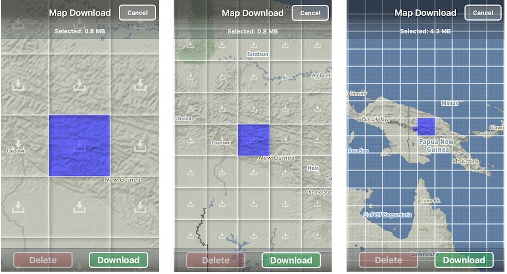
MapOut uses the most recent version of OpenStreetMaps, which is also known as the “Wikipedia of maps”. This open-source data is continually improving as anyone can add streets and modify the maps as need be.
You only download the tiles you need, which work out to be a couple of megabytes each. Once you’ve got your maps, you will no longer be requiring a cellular network. The GPS chip in your phone will find the satellites all by itself.
Topographic Maps for Backcountry Cycling
 The MapOut app is perfect for backcountry navigation because it shows both contour lines and hiking trails. At maximum zoom, the app shows 10-metre contour increments, but as you zoom out that lifts to 50-metres. In the settings menu, you can, of course, switch everything across to miles/feet.
You also have a raft of overlay options that you can turn on and off, including bicycle networks, hiking routes, MTB routes and public transport networks.
Route Drawing: Snap to Road Network
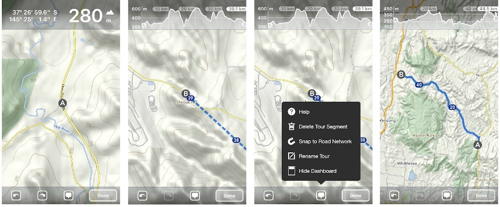
It’s very easy to draw a route. You’ll first need to select ‘draw new tour’. Double-tap to create a starting location ‘A’ and the app will provide the elevation of the site. Zoom out and find your end location. Single tap to create an end location ‘B’. You will now see an elevation profile and the straight line distance between A and B.
You can then ‘Snap to Road Network’. This will pick one of the more direct routes for you to follow. You’ll see an amended elevation profile with distance markers the whole way.
Route Drawing: Using Your Finger
You can manually draw routes too. This is probably the best part about the MapOut app – it’s so intuitive!
Once you’ve plotted the start of your route, drag your finger along the roads that you’d like to follow and it will automatically ‘snap to road network’. Don’t worry if you make a mistake – you can backtrack and then follow the correct road.
Route Drawing: Making Adjustments With Your Finger
You can amend both the ‘snap to road network’ and the finger-drawn routes.
The only clincher is that you will need to follow your amended route long enough to connect it back to the original route. I’ve found it’s sometimes easier to draw a rough route through a particular section and amend it in smaller, more precise sections.
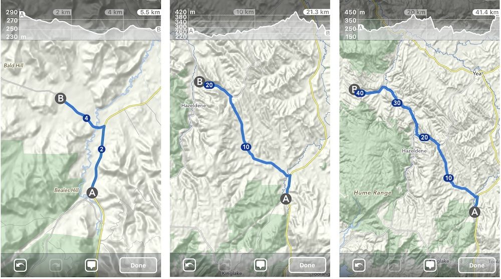
New: Elevation Lost and Gained
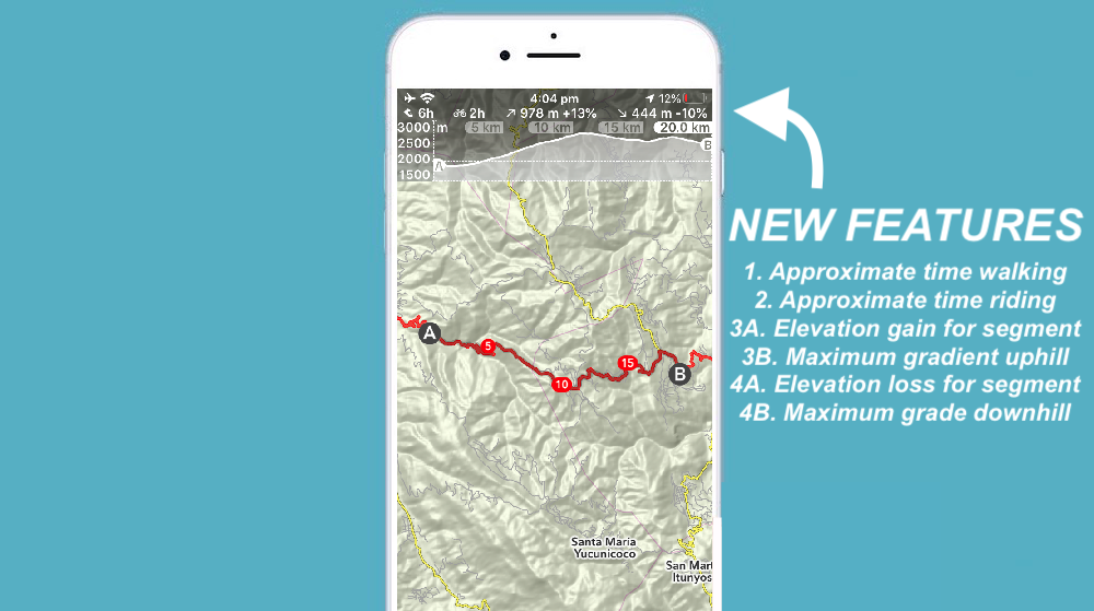
You can see the elevation lost and gained just above the elevation profile, along with the distance, approximate travel times and maximum gradients both up and down.
Analyse Specific Sections Of Your Route
With your saved routes you can analyse specific sections both before you leave or while you’re cycling.
You can drag the ‘A’ and ‘B’ to the particular section and it will give you the elevation profile and distance markers. Alternatively, you can zoom into a particular route section and click on the route itself. The ‘A’ and ‘B’ will now be located within the bounds of your smartphone screen.
If you’re cycling on the route, you’ll see a blue dot on both the elevation profile and map with your exact position.
3D Tilt
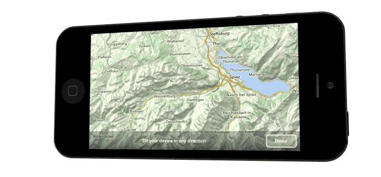
One of the ‘wow’ features of MapOut is the 3D tilt. The tilt gives you an instant understanding of the terrain, almost like you’re viewing from an aeroplane. I regularly use this feature to make sure I get the flattest possible route.
Instant Elevation Profiles and Distance
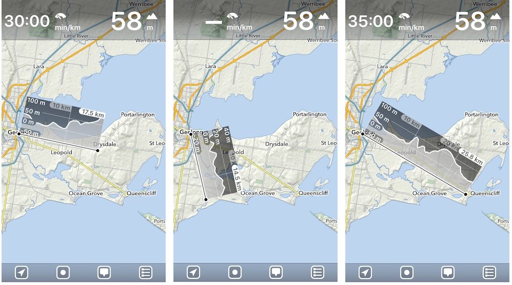
A less known feature in MapOut is the ability to measure both point-to-point distances as well as create instant elevation profiles. These can be useful when determining how far it is to the next town, or how hilly a detour may be.
To see the instant profile, you just need to hold two fingers on the screen at once. An elevation profile will appear with moveable black dots on either end.
Import GPX and KML Routes
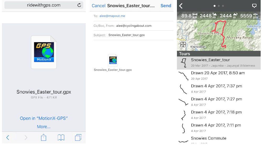
You can easily import routes that you’ve created in RideWithGPS or Google Maps (or any other software).
You’ll need to create a MapOut profile which sets up a personal MapOut email. Then it’s simply a case of emailing your MapOut account with the GPX file. It will automatically appear in your ‘Tours’ within minutes.
Alternatively, you can open the GPX file directly into the MapOut app which will save the route to your ‘Tours’ instantly.
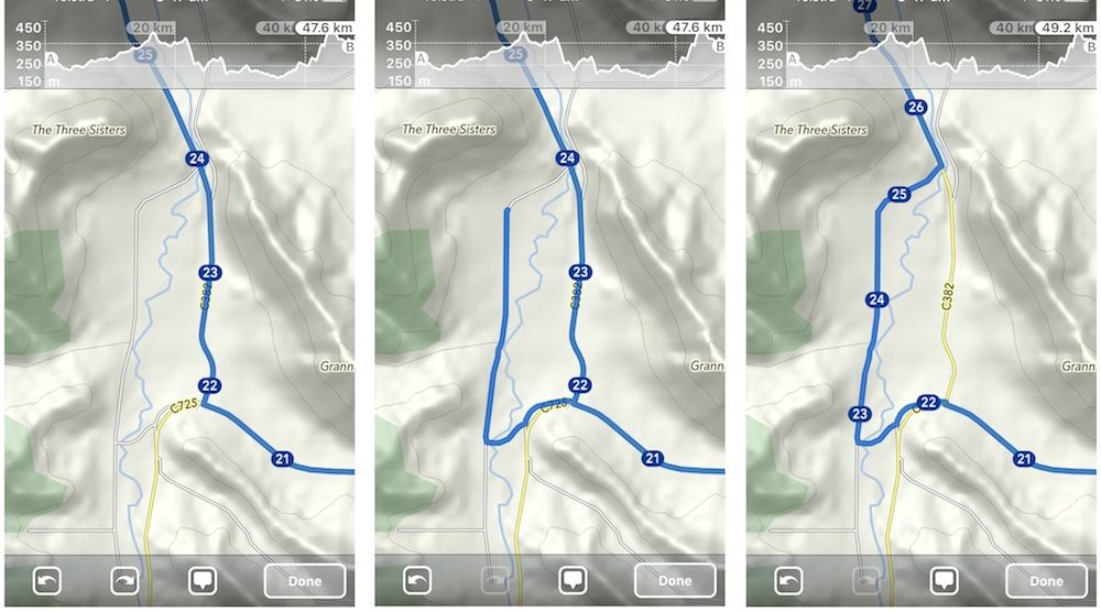
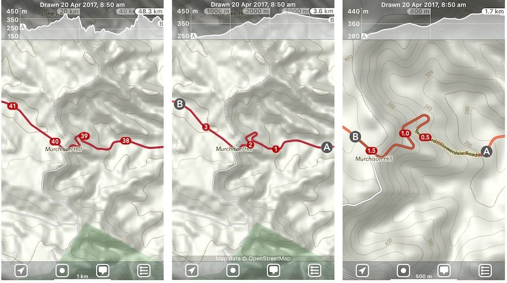
Snap To Road Network – GPX Files
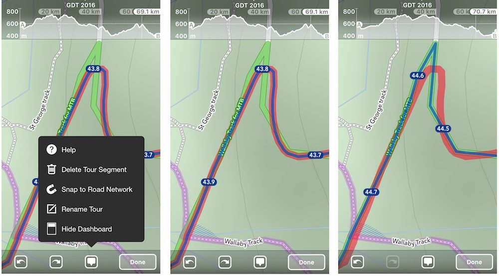
With GPX files that have been recorded with a GPS device, the route is never precisely on the roads. With MapOut you can use the ‘snap to road network’ feature to tidy up existing GPX files that you have. By tidying everything up it gives a more accurate distance and elevation profile.
Take a look at the images below. Once I had snapped the route to the road network, I added almost a full kilometre to my route within the first 44km.
Export GPX Routes
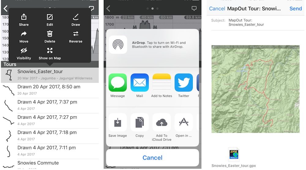
Not only can you import your RideWithGPS, Google Maps and Google Earth routes, but you can share the routes you create in the MapOut app too.
The process is simple. After saving the route you’ve drawn, head to the ‘Tours’ section. In the top-right corner, you’ll see a speech bubble which will give you the option to ‘share’ your file. You can then mail/message/open the route in any other software.
Click HERE to See The 20 Best Offline GPS Apps For Smartphone Navigation
Alee, will it snap to roads without an internet connection? Gaia cant.
Absolutely!
This looks really interesting. Thank you. I have a few questions….
1. After the purchase is there any subscription?
2. If no data is required for use, how is battery life?
3. (Maybe the hardest) Regarding the “tiles” which are downloaded…. Can you guesstimate how many tiles might be needed for a 100 mile ride? In other words if it were possible to ride a straight line out 50 and back 50, are we talk 3 tiles or 75?
1. No subscription. It’s a one off purchase.
2. Battery life is always better in flight mode!
3. I just highlighted 100 square miles of tiles over Sydney (big city) and it was 13mb. The same amount of miles in a rural area was 3mb. If you zoom out enough that’s just one tile (they get bigger the further you’re zoomed out).
OsmAnd 2.6 for android has nice route analyze/browse feature, it can calculate route for you offline using vector maps and can take elevation into account, standard map of whole australia takes 365 mb
Thanks for the suggestion. Is it easy to modify your routes once they’ve been calculated?
you can drop and organize any number of waypoints and let it recalculate route
there are some route editing features but i find it easier this way
can i make a route, then Export it as a gpx so i can Import it to my garmin 820?
Yep!
Downloaded yesterday to my ipad and I love it. Thanks for bringing this app to my attention!
iOS only 🙁
Yeah! 🙁
(Lots of folks are recommending OsmAnd 2.6 as an Android alternative)
Recommend you try Backcountry Navigator Topo on Android (https://play.google.com/store/apps/details?id=com.crittermap.backcountrynavigator.license&hl=en). It can use dozens of map source options, including OpenStreet Bike maps and the newer US Forest Service topos (US only obviously). Not affiliated with them in any way. Just an enthusiastic end user.
Thanks for the suggestions, Greg.
I have been using Osmand for years and I am quite happy with it. I do most of my route planning on the PC using Garmin Basecamp, with the following workflow:
– download the appropriate OSM map areas to the PC in Garmin format
– plan the routes, frequently using Basecamp in one window and Google Maps in another
– download the maps to my GPS
– download the GPX routes and waypoints to my GPS
However I don’t want to rely on a single electronic device so I also:
– go to Osmand on my phone and download the relevant maps
– download the GPX routes and waypoints
– go to Google maps and cache the relevant tiles (mostly the towns)
So then I have three sources of mapping data which all work offline.