

In this resource, we’ll take a look at the best offline GPS apps for navigation on a smartphone. I can almost guarantee the list here will have you covered for all your mapping needs. App features in 2018 include routing, tracking, elevation profiles, turn-by-turn voice prompting, GPX importing, map layering, route drawing, live tracking, Wikipedia entries, hotel booking and the ability to select different types of maps depending on where you’re riding. With functionality like that, it’s clear that smartphones make really powerful GPS systems.
The thing these apps all have in common is that you can download the mapping information and use it without internet access. That’s right, you won’t need wifi or a sim card. Just ride, map and navigate.
For more on navigating with a smartphone, check out:
GPS Navigation: How To Go Bicycle Touring with a Smartphone
The Best Bike Smartphone Cases & Mounts for Cycling
Offline GPS Apps
*Ratings collected in June 2018
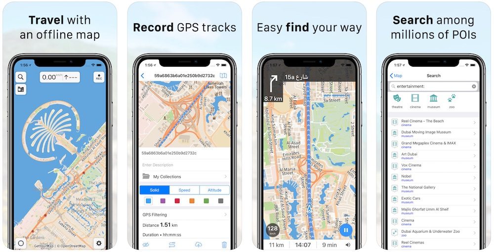
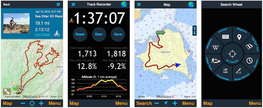
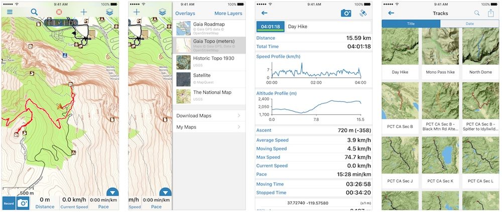
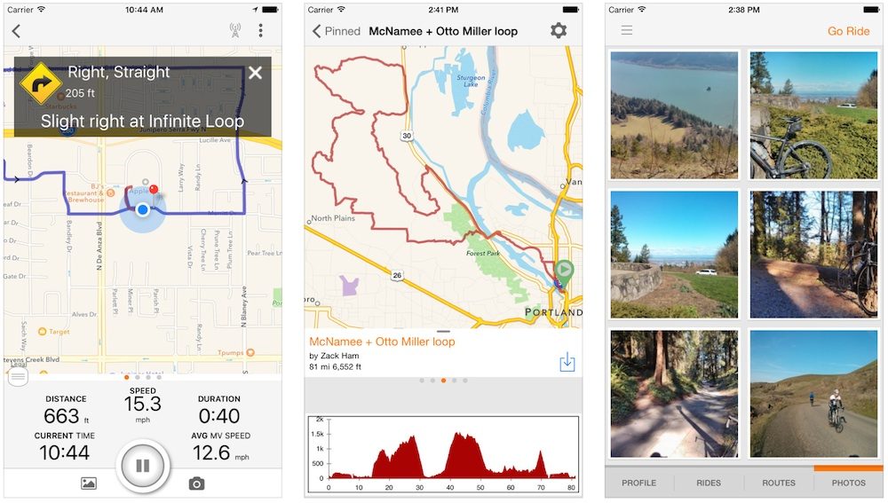
This relatively new app seems to offer everything! To create a route, you can trace with your finger and snap it to the road network. There are interactive elevation profiles, downloadable map tiles, topo/terrain maps, GPX/KML importing and 3D tilt to see the topography of the region. For everything other than services (restaurant, hotel etc), this is as it gets for bicycle touring! Head HERE to read my usage guide.
App Store Rating: 4.8/5

One of the most powerful offline mapping apps for iOS has recently had a big update. There’s now millions of POIs, ability to record routes and navigate offline. With this app, you can also upload your own custom maps in a number of formats for easy navigation.
App Store Rating: 4.8/5
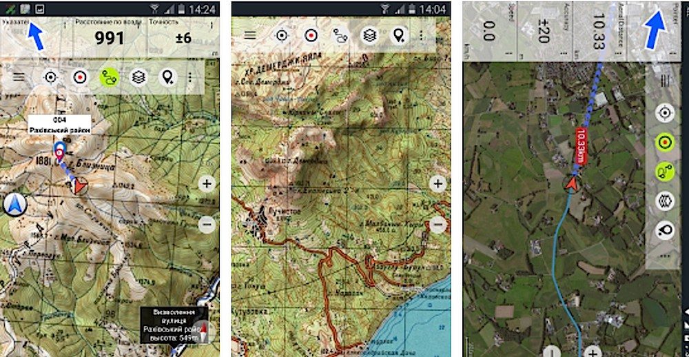
Locus is the highest-rated navigation app for Android users. It has access to huge quantities of different maps (inc. terrain, cycling, hiking, skiing), either while you use data, or as in-app purchases for offline use. You can import custom maps, enjoy turn-by-turn voice navigation or understand places with the incorporated Wikipedia information. This app is really powerful!
Play Store Rating: 4.7/5
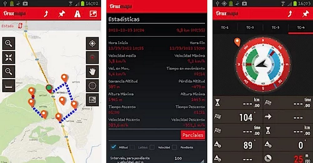
OruxMaps Offline Maps (Android)
Orux is generally considered the best Android mapping app because it is free and has an incredible raft of features. It will take you some time to familiarise yourself with these features because the user interface isn’t exactly polished, but essentially you can upload all kinds of maps and tiles including GPX, routing, have different user profiles and even track your route (live tracking with an internet connection).
Play Store Rating: 4.7/5
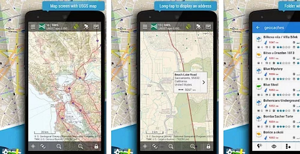
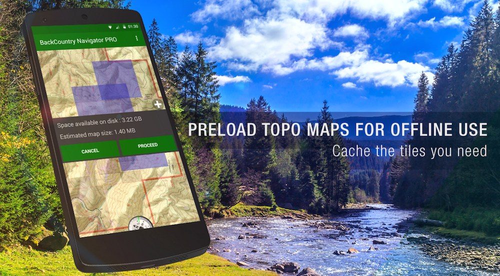
This backcountry app allows you to create, display and save an unlimited number of waypoints, routes, areas and tracks. You can set up multiple maps in layers, with per-map opacity control. You’ll also have access to many map formats including Nokia maps, Yahoo maps, local topo maps etc.
Play Store Rating: 4.7/5
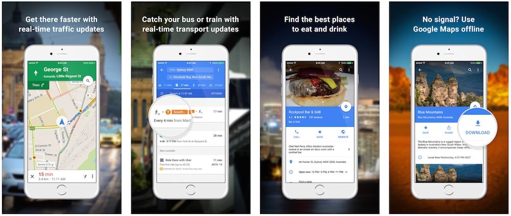
Easily the most elegant and up-to-date of all smartphone maps, however, they are best used with data. It’s possible to save the Google Maps in the cache (to view it offline). While you have an internet connection, zoom in on a part of a map that you want to save. Type “OK Maps” (minus the quotes) and hit Search and you can save highly detailed maps out at 15km if you need. Google Maps also allows you to view larger regions offline, by caching any areas you view; just remember to zoom into any areas you’ll need to view in more detail later. The turn-by-turn directions even work offline if you search for them while you’re connected to wifi and continue travelling without.
App Store Rating: 4.7/5
City Maps 2Go Offline Maps (iOS/Android)
For a couple of dollars, you can download maps for all countries in the world which are stored on your device. The map data is provided by OpenStreetMap which is a collaborative open source database with information provided by hundreds and thousands of people. This app has inbuilt Wikipedia and WikiTravel information which can be found at landmarks on the maps.
App Store Rating: 4.6/5
Maps.Me Offline Maps (iOS/Android)
Maps.Me isn’t as powerful as other apps, or as beautiful as Google Maps, but the user interface is great and it packs in a lot of searchable travel information on restaurants, hotels, campgrounds, hospitals, police stations etc. The map data is provided by OpenStreetMap (OSM) which is a collaborative open source database with information provided by hundreds and thousands of people. It’s easy to get maps, simply download the countries you need in the app (usually 5-500mb per country) when you have a good internet connection. Using the cycling navigation option, you will even find elevation profiles. Here’s a resource on how to import a custom KML route into the app.
App Store Rating: 4.5/5
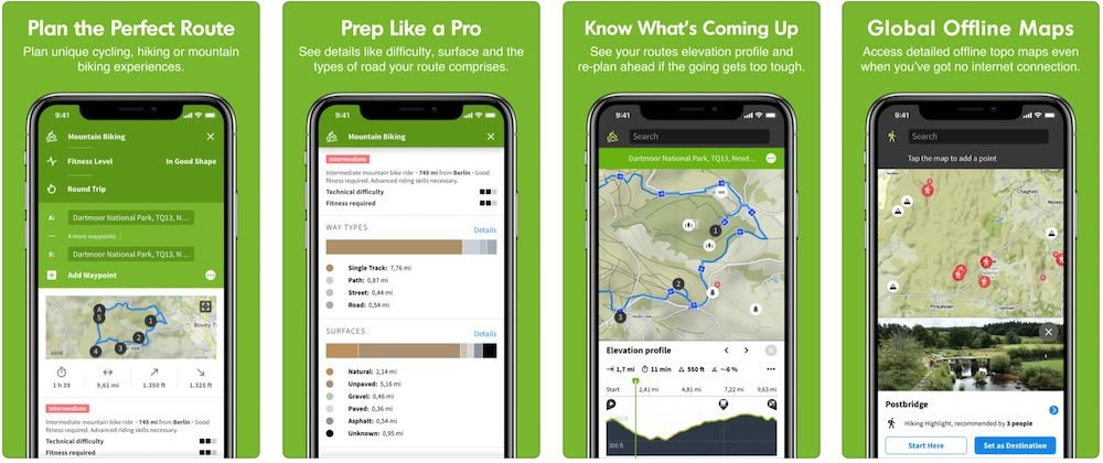
Komoot uses one of the most impressive map data sets I’ve used for routing – I don’t think there is a better app for planning a route. You can choose various types of road surface to match the capabilities of your bike. The app will even show you the distance break-down of each surface. The turn-by-turn voice navigation is perfect. The biggest downside is that the offline maps take up a LOT of storage space. Even if you decide not to use this app, you can plan your routes on a computer and export them to other apps HERE.
Play Store Rating: 4.5/5
This is another top iOS app for a backcountry use. Download the maps within the app and enjoy travelling on back roads and hiking trails with detailed topo maps. Super easy to plan, track and store your exploits.
App Store Rating: 4.5/5
Backcountry Navigator Topo GPS (Andoid)
This top-selling backcountry app has OpenStreetMap and OpenCycleMap information available for download, so it’s not just good off the beaten path. It’s also super easy to import GPX/KML information / GPS coordinate information – here’s a great guide to using it.
Play Store Rating: 4.5/5
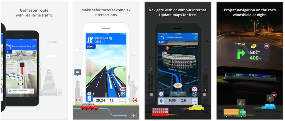
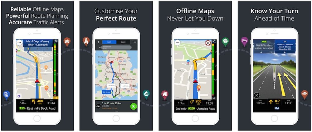
Sygic is the world’s most downloaded offline navigation app. It employs high-quality car based maps from TomTom and other providers which are stored on your smartphone allowing you to navigate without an internet connection. The navigation is voice-guided, provides alternative routes and drag and drop routing. The app is free, but you will have to purchase the maps (you can even download the world maps for 111 countries for $30).
App Store Rating: 4.5/5
Pocket Earth PRO Offline Maps (iOS)
This highly rated and powerful iOS app allows you to import and export GPX files, download maps (cities, regions, countries) for offline use, route, turn-by-turn navigate and track your trip. It incorporates 500,000 Wikipedia entries which are incredibly useful for finding points of interest while travelling.
App Store Rating: 4.3/5
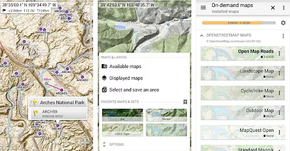
Gaia GPS Topo and Trails (iOS/Android)
This backcountry focused app is highly rated by bike tourers who spend time off the beaten track. With Gaia, you have access to a whole raft of worldwide mapping layers. These topographic, road or aerial ’tiles’ can be downloaded to different levels of detail, resulting in different file sizes. If you’re a ‘pro’ user you’ll be able to layer multiple maps at once. You can of course import/export your own GPX/KML files by web browser, DropBox and email. The app isn’t as cheap as other options (US $20) but once you’ve invested, all map downloads are free within the app.
Play Store Rating: 4.3/5
Soviet Military Maps Free (Android)
These downloadable world topo maps (100k-500k) are former Soviet military (mostly from 1980’s), and for many countries in Africa and Asia are still the best topo maps available!
Play Store Rating: 4.3/5
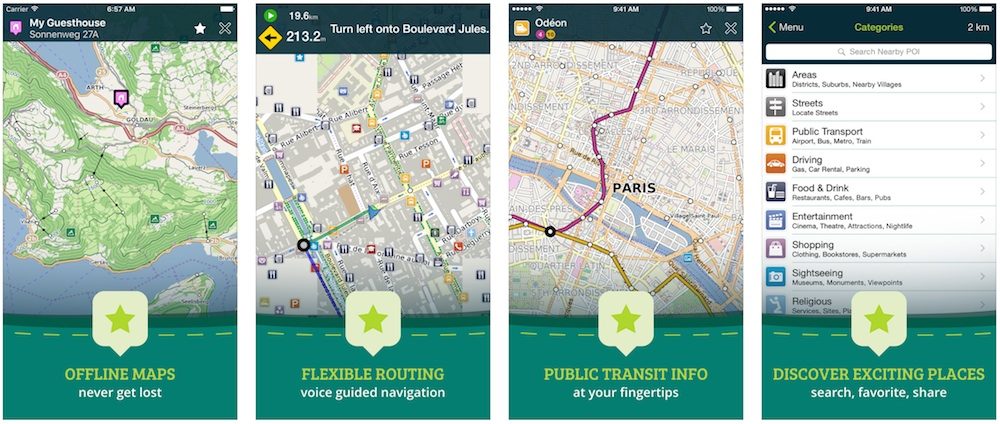
As the name suggests, this app has access to OpenStreetMap data which can be downloaded to your phone through the app for offline use. If you don’t want to store maps, you can also use mobile data to access maps. A great feature of this app is the cycling and walking routes. This app includes navigation features such as voice guidance and re-routing. You can also search for addresses and find GPS coordinates.
Play Store Rating: 4.2/5
This app is free and has lots of offline maps available. For iOS users, this is one of the better apps for offline searching and routing. You’ll need to purchase features such as turn-by-turn and voice navigation for a modest amount.
App Store Rating: 4.2/5
Ride With GPS is more of a cycle computer that has inbuilt navigation and live tracking. It even supports Bluetooth accessories for adding heart rate, cadence and speed data. There is seamless GPX importing from the Ride With GPS website but you will have to pre-download the individual map tiles.
Play Store Rating: 4.1/5
The HERE maps are going from strength to strength currently. The mapping interface is really simple, clean and easy to use. HERE features GPS turn-by-turn navigation with elevation profiling and the elevation gained/lost. There are lots of waypoints available from restaurants to Wikipedia entries. You can download entire continents if you have the storage, or alternatively download each country. The best bit? It’s free!
App Store Rating: 4.1/5
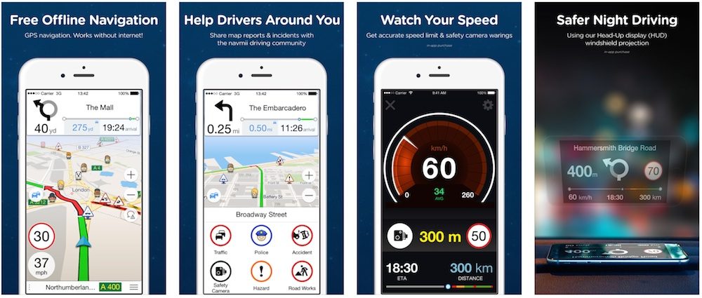
Navmii Offline Navigation Maps (iOS/Android)
This highly popular OSM app has great features including offline mapping, routing, re-routing, turn-by-turn navigation, Google street view and more.
Play Store Rating: 3.3/5
Take A Look At…
GPS Navigation: How To GO Bike Touring with a Smartphone
The Best Bike Smartphone Cases & Mounts for Cycling
Hey Alex,
As an Android user it took me a while to find a fitting solution for our navigation. I’ve come to like Orux considerably and use it for everything now, although I hear that other Android users are as happy with Locus. Both can make use of offline maps like OpenAndroidMaps (http://www.openandromaps.org/en/downloads) and offline routing software such as BRouter (http://brensche.de/brouter/). I think OsmAnd uses BRouter for its routing too. BRouter is the dog’s nuts!
So anyway, we just crossed into crazy Vietnam. At least it seems crazy after a very relaxed Laos. Heading for Hanoi. Maybe our paths will cross again down near Cambodia… 😉
Cheers,
Will.
Thanks for your input, Will. I’ve added a bit more info into our article. Hope to see you again in Vietnam/Canbodia!
Just tested “brouter” with free “Locus” on Android 2.1. Works very fine, “nogo” areas in meters (radius) can be added.
(See Will’s links below: http://brensche.de/brouter/)
The app is now on sale. You can also use the additional 25% discount by entering a discount code, e.g. REF5620RPSBHC1198
Check Bikemap 😉
Thanks, great information
No problem!
‘Sketch a Track’ for Android (https://play.google.com/store/apps/details?id=com.wolfgangknecht.sketchatrack) could be interesting for you guys to create GPX tracks. You can draw tracks directly on the map and you also get an elevation chart.
The app also works great in combination with the Samsung Gear/Gear 2 to get the tracks on your wrist.
I’m the developer of the mentioned app and would be happy if you give it a try!
Absolutely awesome wrap up article on this subject. Even if you didn’t intend this, it’s a great list for hiking and skiing too.
Uhmmm hey.. What about uuhm idunno, Windows phone???
http://www.theridingobsession.com/motorcycle-touring/motorcycle-digital/custom-motorcycle-route-voice-guided-gps-navigation/
I’m surprised Nokia Here maps is not mentioned. It is far better than any option mentioned above. It has offline turn by turn voice navigation. No caching, no internet connection, no data plan is required. You download entire country maps. For example I downloaded the England map. Now I have offline turn by turn voice navigation anywhere in England. I bought a Nokia Lumia 520 for this. The phone is with me always anyway. I carry a pair of earphones in my keyring pouch. Whenever I need navigation, I select the destination, put on the earphones and keep the phone in my pocket.
As far as I know Google maps doesn’t do offline voice navigation. I think none of the options mentioned above do it either. Nokia Here maps is available on Android too. When I bought the phone it wasn’t. I think they added it back in Oct 2014.
I just started using Pozzr (pozzr.com) and it works well so far. Has anyone else tried it?
Question:
What Android app allows you to research plan and map out a route on a web browser, and then follow that route on your phone with voice and turn by turn guidance..?
For example I want to plan a weekend bicycle tour on my desktop PC, map out the route, mark points of interest etc and then follow that route using my smartphone as a multifunction GPS guidance device.
I have tried bikehub.net but the main let down is that it doesn’t have turn by turn voice navigation, so you always have to look at the phone to check you’re on track.. Apparently they are planning to add better guidance in the future, but I need something now.
Suggestions? Cheers
Have you tried using Ride With GPS to create custom routes? That’s my favourite way build GPX routes: https://www.cyclingabout.com/ridewithgps-create-export-routes-smartphone/
You can then import the GPX files into Locus Maps Pro for Android and you’re good to go. Let me know how it all works out.
Alee
What I would really like is to have all this functionality in one package and account, rather than having to do multiple steps with different websites and apps etc.
As I said, bikehub.net is pretty close as it offers web based and app access. However the navigation it currently uses is terrible to use while riding.
If someone combined bikehub.net with the navigation power and functionality of HERE that would be a perfect app for bike touring!
In that case, Alee is right. RideWithGPS.com has it’s own app which makes use of your saved routes. Moreover, it’s always getting better and is pretty intuitive. Yes, it costs. Otherwise, you’re looking at multiple resources, such as the ones mentioned in our motorcycle instructional (good for bicycling and other activities as well) … http://www.theridingobsession.com/?p=3198
Hi Alee. Great advice. Was playing with maps.me, looks perfect for my New Zealand needs.
To my joy also found that rankers.co.nz has also brought out apps with maps – loaded it last night and it looks simple, clean, and very effective for locating campsites along the way.
You can pre-load the NZ maps to use offline with a good degree of resolution in built up areas.
It picks up on the reviews and campsites on the Rankers sit – so basically it shows you all the camping spots all over, including DOC sites as well as the rankers summary and ratings.
Rankers was great last summer for finding places to camp, especially freedom camping option. Now even easier with pre-loaded maps via the app.
Currently on tour from Peru to Patagonia and using ‘MapOut’ on my iPhone. Do check it out – it’s by far and away the best mapping app for iPhone that I’ve found. Crucially, it does:
– Great elevation profiles – just click on your route on-screen and it shows a profile of the portion currently visible on-screen and where you are on it. Invaluable when travelling in mountainous areas!
– Easy routing – just trace with your finger and it snaps to the road network.
– Offline maps – easy to select required tiles, small download size and fast rendering. OSM maps with terrain.
– Import/export of routes – easy and lots of options.
…and lots more!
http://mapoutapp.com/en/
I’ve absolutely no affiliation to them but have recommended it to every iPhone tourer I’ve met and they’ve all loved it! It’s been the envy of many Android users too. Easily worth the £4 or so that it costs.
komoot.de is my preferred routing app. Its specialiced for bike traveling and comes with offline riding. simple but very useful, imho.
Well thanks for another useful list that will keep me busy during my down time.
Did you take a look at Avenza Maps? I mostly use it for MTBing but it seems like it would be handy for a back country trip as well. The fact that I can use it is a testament to it being easy to use.
Hi Paul. I haven’t seen Avenza, I’ll check it out!
Nice write up, I appreciate the number of apps you covered. Did you end up using all the apps to give your ratings? I wrote something similar on our LongHaulTrekkers.com :
http://longhaultrekkers.com/the-best-offline-mapping-tools-for-cycle-touring/
The ratings are based on the reviews in the App Store / Google Play. But I have played with most of these in any case.
About Android apps. Can you advise on any app to keep a log of your bicycle maintenance schedule. For the moment, I use ordinary txt file. Do you know any good Android app to keep track of all the changes, repairs, maintenance done on the bicycle?
I don’t know any personally, but someone else might be able to chime in here. Let us know how you go.
Well, for the moment, I found Bike Repair app. Apart from tips on repairing the bike, there is My Bike profie where you can describe all components of your bike and make notes regarding maintenance done. Also, it is possible to backup and restore your bike data. The app is not without problems. I’ve had several sudden crashes but this is at least something. Now, it’s easier to browse through data regarding what and where was changed and maintained should a mechanic ask.
Great article ! You know that when going to hike for a long time the charging is usually what comes first to mind … my other concern used to be durability; Which was solved when I bought the x1 (I leave a review: thatagmdude.blogspot.com/2017/03/RDeen0Xagmx1part1.html … in general camping is a lot of foresight, foresight and foresight! : D Btw: now the agm x1 has a gold edition and i hope can get one soon 🙂
With my agm x1 i can use as a GPS on my hikes without needing a weatherproof case and still have battery left over; you know: rugged phone! The cool thing about it is its price: really cheap for the specs. Well, great note ! Thank you for sahring
Hi!
This is an older article but a newer app which is very good (I use it for, road biking, mountain biking, bike touring, hiking…) is KOMOOT, it has the ability to be used off line and a good rout planner!
Hi, great summary, with very useful info!
Specifically for turn-to-turn guidance, I´d like to choose GPX files from community and follow voice directions while I´m biking… which are the best apps in your opinion?
This is nothing related to offline vs. online usage, but with the possibility to load a route and listen to a guiding voice while enjoying the nature. Thanks!!
Thanks Kieran. I’m currently testing Komoot and will add it soon!
Most of these apps will have voice guidance. I’d suggest trying a few and seeing what you find the most intuitive.
about this gear sports… humm … imo AGM Its a amazing rugged line for Sports ! Best ppr in ruggeds, Check out the reviews of the x1 in that blog thatagmdude.blogspot.com/2017/03/RDeen0Xagmx1part1.html ! ( the gold edition of the x1 is amazing) quite complete , too That been said i think is important that a phone is not only rugged but has a responsive custom service :O ! ( agm does have one in english btw)
Anything but Hangbiker, please … ahahha…. I just somedays take the long road to home , my agm x1 ( great rugged phone), some music and enjoy the afternoon 🙂 i love being able to do it.
I love the social aspect of STRAVA to compete with other cyclists! I get on the bike; my headset on, agm x1 (a phone that endurance falls, water, aaaalll) some water … and I lose a few hours in the road ♥
With my agm x1 ( a reeeally resistent phone that i can use as a GPS ) on my bike without needing a weatherproof case and still have battery left over i used to ride hours along the coast— meeen i ll like to have that time again…. My phone still rocks btw. xD
Great ! always a “thing to do ” before a cycling , … my tip on this will be … well: used to worry about durability but i discovered AGM 🙂 I have checked out the review on thatagmdude(dot)blogspot(dot)com/2017/03/RDeen0Xagmx1part1(dot)html is ridiculous how good the gold x1 is for less than 300 euros… more if you are as clumsy as me and the phone is gonna meet the floor a lot xP NOTE: its waterproof BUT you might want to put a chain in it since doesnt float or come back by itself xP
again thx for the note!!
yeah… lets just ignore that ‘phase’ of Microsoft he…
Why the hell doesn’t anyone support Window’s phones? Am I the only one on the planet that has one. It works great and integrates with my PC far better than Android or an Apple…wtf?
Windows Phone unfortunately never gained traction and has been discontinued by Microsoft. If you wanted an anecdotal recommendation, I personally like CoPilot GPS, which I believe has a Windows Phone version.
thanks for the info internet stranger…I was expecting to be called an idiot or something which is usually the internet response. 🙂
Faydalı bilgilerinizi bizlerle paylaştığınız için teşekkür ederim, brezilya hakkında bilgi sahibi oldum.
escort site adresleri ile sende hemen tıkla escort bayanlara ulaş.
Your blog post had me hooked from the very beginning!
Leave a comment and let us know what your favorite blog post has been so far!